By Daniela Del Bene.
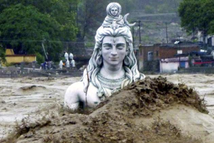
Do you remember the dramatic floods in the Western Indian Himalayas back in 2012? We blogged about the Uttarakhand disaster and about the thousands of victims, while watching images of rescue operations in helicopters and reporters describing the dramatic situation on national TV channels. Yet, the neighboring state of Himachal Pradesh should have got the same national and international attention. In the valleys of bordering districts of Kinnaur and Shimla, flooding waters were destroying villages and submerging fields, while leaving thousands of people dead. More recent alike events occurred in the North-western district of Chamba in March 2015, when a massive landslide triggered by heavy rains damaged the Saal hydropower project.
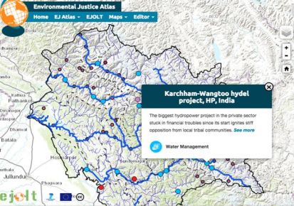
Himachal Pradesh is generally celebrated for its landscape, as the abode of snow and rivers that have always rendered the state a distinct identity. Even today, the state seems somewhat idyllic and ideal – with a semblance of balance. The image is cultivated that the State government is a good provider of welfare services and the mountain people co-existing peacefully with the landscape. In 2000, the state announced its commitment to become the “green state” of India, through fostering so-called renewable energy, clean industries, sustainable tourism models and other progressive policies. However, a closer look reveals that, like in the rest of the country, there is a crisis in the making here. Many protests against hydropower projects are ongoing but also other controversial extractive industries have been going on for decades now. The Featured Map of Environmental Justice in Himachal Pradesh tells the stories of some of them, representing a collective disappointment, but also of the resisting spirit of Himachalis.
Click on one of the major dots to know more about the conflict and the protest
All information is being collected through official documents and reports, reports and articles by organizations and independent analysts like SANDRP and International Rivers, documentation obtained by Himdhara, a local environment action group, through the Right to Information Act and cross-checked with on-the-ground work and substantiated with interviews, newspapers articles and direct observations.
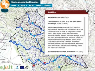
The map contributes to show the pace of construction, the expansion of the hydropower frontier, directly linked to a development model based on unbridled exploitation of natural resources for economic growth.
Click on river lines to read about hydro development in the basin
Considering the ecological fragility of the region, the impacts are very serious. Especially large-scale construction of dams in the Himalayas, pursued by the Union and State governments for fostering economic growth, has alarmed geological experts.
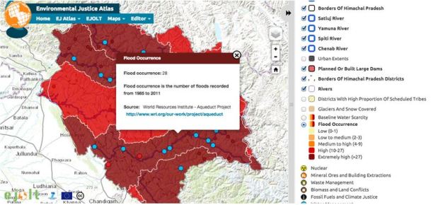
Use GIS data to get information about water stressed areas, flood occourance and snow cover
HESCO’s founder (Himalayan Environmental Studies and Conservation Organization) Dr Anil Prakash Joshi noted that policy makers have not learnt from the tragedies in Kedarnath, Nepal and Pakistan and warned about unparalleled damage if an earthquake strikes the region. Joshi said that even though locals have often confronted government officials over construction of dams, the government has constantly supported large constructions without thinking about the consequences on local people and nature. Even Himachal Pradesh University vice-chancellor A D N Bajpai warned that an earthquake could destroy the entire Kinnaur district of Himachal Pradesh because of the number of tunnels there, used for run-of-river type of technology for hydropower generation. The expert committee of the Ministry of Environment and Forests (MoEF), set up under the direction of the Supreme Court, finally makes the clear connection between the mushrooming of hydropower projects in the region and the 2012 floods.
Apart from impacts and risks, organization like SANDRP and the Manthan Centre argue that despite increased installed potential, large hydroelectric projects have not proven to be efficient nor financially viable. Sandrp writes: “Reports suggest that the state requires about 1200 MW of power, but it is producing so much more that it has no buyers. It is not surprising to see that projects like the 1000 MW Karcham Wangtoo in Kinnaur are facing lack of buyers for electricity. The JPHL has not been able to sign long term Power Purchase Agreements (PPAs) with any power distribution company (discoms). As a result, it is selling electricity through short term agreements or at lower prices. This is the situation with a lot of other plants in the state, both private and public. Even after facing such losses, why is it that the Himachal government is pushing for more and more projects, destroying the rivers, forests, biodiversity, livelihoods and environment?”
Instead of pursing unconditionally an abstract economic growth, why don’t we change our road map to well being through a true environmental justice, defining priorities and needs as well as the appropriate technology to the local conditions? This map wants to draw attention to the risks, the paradoxes of dam industry, the reasons of resistance, and to remind that in these and in many other socio-environmental cases, dissent matters and its voice should not be dismissed.
The authors are grateful to the Fundaciò Autonoma Solidaria of the Autonomous University of Barcelona for partly funding the research and technical work behind the map.


Pingback: Mapping environmental conflicts in Himachal Pradesh | Himdhara
Pingback: DRP News Bulletin 25 Jan. 2016 (Save & Grow: FAO supports SRI) | SANDRP
Nice initiative & informative